
29.07.2015 | Frederik Ramm
A new, world-wide water and waterway debug layer is live at the OSM Inspector web site. We’ve done away with the old VMAP0 river reference, and extended coverage from Europe-only to the whole planet.
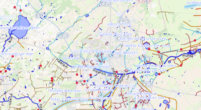
There’s tons of new features – for example, OSMI will detect when a river changes its name, or starts out of nowhere (or ends in something that is not another body of water).
Rivers without names are highlighted, as are directional problems where two parts of a river flow towards, or away from, the same point.
The software backing these new layers has been written in C++ (using Jochen Topf’s excellent Osmium library) by Geofabrik intern Nathanael Lang. It is Free Software, and can be run in a standalone fashion to convert an OSM .pbf file into a SQLite database if you’d like to run your own analyses. Fork it, or report issues, on GitHub!
11.04.2014 | Frederik Ramm
For over 5 years now, Geofabrik’s OSM Inspector is an important quality assurance tool for OpenStreetMap, used by thousands of mappers on a daily basis to check their local area or their own work.
Some of the Inspector’s layers, like for example the routing problem analysis or the broken multipolygon view, have already been available world-wide for a while; but others were restricted to Europe because of limited resources.
Today we announce the launch of a world-wide address layer, highlighting mistyped addresses, addresses without matching roads, bad interpolation ranges, and other common problems with addresses in OpenStreetMap. The new view is available from the standard view select drop-down in OSM Inspector, replacing the previous Europe-only layer.

This view was previously computed by a relatively slow process based on a PostGIS backend, and now uses a completely new standalone backend that is based on Jochen Topf’s new Osmium library, and available on GitHub.
![]() This launch is made possible by a generous hardware sponsorship from Canadian telematics company Geotab Inc. – thank you!
This launch is made possible by a generous hardware sponsorship from Canadian telematics company Geotab Inc. – thank you!
We’d also like to thank Lukas Toggenburger, who developed the new OSMI address backend as part of a project thesis for his master studies at HTW Chur, in Switzerland, in a cooperation with HSR Rapperswil.
11.02.2014 | Frederik Ramm
The OpenStreetMap Foundation is an English non-profit organisation created to support the OpenStreetMap project. It has about 500 individual members. The Foundation pays for the servers on which OSM is run, organises the yearly “State of the Map” conference, and last not least also has to deal with the legal aspects of running a world-wide, crowd-sourced mapping project. Foundation work is done by volunteers entirely (one of which is this author), but of course money is needed for hardware and hosting, accounting, legal fees, and various bits and pieces that help the volunteers do their jobs.
Since the Foundation’s last Annual General Meeting in September 2013, the Foundation is open to corporate members.
You can now be among the first who publicly show their support for the OpenStreetMap project by signing up as a corporate OSMF member. The membership fee is £1,000 per year (at current rates, that’s €1,200 and US$1,650). Your membership fees will help to keep OpenStreetMap’s servers running and ensure the continued success of the project.
Read more on the OSM Foundation blog.
Geofabrik, of course, has joined already, and we encourage our friends and clients to do likewise.
19.11.2013 | Frederik Ramm
The other day we were asked to quickly throw together an “offline map” for laptop use by crisis responders in the Philippines. We had a couple of hours to create something that was simple and rugged, something that ideally runs on any operating system without having to install software.
We knew that you can easily use OpenLayers or Leaflet plus a directory of pre-produced tile PNG images and then access that with a “file://” type URL from your local browser. This solution can even be run from an USB stick without any software installation, and any halfway recent browser works – be it OSX, Windows, Linux, or even more exotic operating systems. There are many more sophisticated solutions – storing vector data on the device gives you more interactivity and detail at a fraction of the disk space, or if using raster tiles, storing them in MBTiles format is less clumsy because it’s just a single file. All these options require some software installation though. So we decided to go with the old-style technology – but we made one minor tweak that made our solution much more useful on certain systems.

Because our set of tiles might be used on computers that use FAT file systems – crucially, most USB sticks or external USB drives will come formatted with that -, we had to take into account that FAT allocates space in full clusters. Even a small 500-byte PNG will consume one full cluster; and the cluster size on FAT systems can go up to 32 kB. With many high-zoom tiles being near empty, this means we’re wasting a lot of space.
The area we were exporting was about 2 GB of image data. The red and orange lines in the above image show how much disk space this would have used had we stored single 256×256 pixel tiles (the standard size) on a FAT system with 8 kB or 32 kB cluster size. Zoom level 18 tiles for the area in question would have taken 25 GB on a volume with an 8kB cluster size, and almost 100 GB (shooting out of the graph) with a 32kB cluster size.
Instead, we opted for making non-standard tiles with 1024×1024 pixels, 16 times as big as standard tiles. This puts more of the map in every single image, and reduces the waste incurred by “rounding up” to the nearest cluster size dramatically. OpenLayers accepts a “tileSize” parameter and processes the non-standard tiles flawlessly.
Unpacking our tiles down to z18 now only takes 6 GB on a volume with a 32 kB cluster size, and 3 GB if the cluster size is 8 kB – perfect for a “map-on-a-stick”!
If you find yourself in a similar situation – there are probably many ways to generate tiles like these, but we used Tirex which we configured to use large tiles (config option tilesize=1024), and then converted the resulting meta tiles to simple PNGs with the meta2tile utility. Remember that when doing this, you’ll only compute tiles down to a nominal zoom level of 16 which, because each tile has 1024×1024 pixels, gives you the same amount of detail that you’d normally see at zoom level 18. Then, in OpenLayers, you’ll have something like var map = new OpenLayers.Map('map', { tileSize: new OpenLayers.Size(1024, 1024) }) to work with these tiles.
(Hat tip to Matt Amos and Ian Dees on whose ideas we based this.)
1.10.2013 | Frederik Ramm
(Deutsche Version in eigenem Artikel.)
Geofabrik is a household name in OpenStreetMap circles, but even insiders often ask us: What is it that you do at Geofabrik, apart from all the handy things for the community? What’s your business model?
We like to respond like this: At Geofabrik, we’re essentially craftspeople. Something like carpenters or cabinetmakers. Clients come to us and say “can you build me a cupboard”, and then we discuss the details with them, make them an offer, and when they like what we suggest, then we’ll build the cupboard. Of course the analogy only works so far – at Geofabrik, we might be able to build a standard cupboard for a client, which makes things easier. For another client we might, after a longer discussion, suggest that they get a nightstand instead because it serves them better, or we might offer to store their stuff in one of our cupboards. Or maybe we find out that they’re rather good at woodworking themselves and we just give them a blueprint for building their own cupboard… but what we like about the analogy is the the “honest work” aspect. We’re not “in the cloud”, we’re a solid engineering company, and we’re masters of our trade.
Since its inception in 2007, Geofabrik has done lots of different projects, sold products or services, and we’ve finally come up with a web page that presents a selection of them so that you can see for yourself what it is that we do.
For those that are interested further, Frederik has held a talk at the State of the Map US with an inside view of what it is like to do business in OSM.
And no, there aren’t any cupoards on that page, or in that talk.