
30.06.2017 | Michael Reichert
We have rolled out some changes to the OpenStreetMap Inspector in the last days. They affect the views Geometry, Tagging, Places and Highways.
From now on the data which powers the rendering of these views is generated by a tool called osmi_simpleviews. We released its code on Github under GPLv3. It’s a C++ program which uses the libosmium library by Jochen Topf to read the planet and work with the objects in it, and GDAL to write the errors to a Spatialite database (other formats are also possible, but not properly tested). It generates one Spatialite file per view. It’s open source and you can run it on your own.
The Spatialite database is copied from a processing server at Hetzner’s data centre to the machine where all our tools available at tools.geofabrik.de are hosted on. It uses the Spatialite file as a data source for the WMS service (Mapserver).
While the main goal was to reimplement things in C++ (instead of Perl and C previously), we changed some things which we want to explain here. Have a look at the OpenStreetMap Wiki where the full documentation of the views is located.
This view (documentation) shows errors and potential errors regarding the geometry of ways.
Tagging errors and strange tags are shown by the Tagging view (documentation).
fixme=* and todo=* or which has any key with the value fixme. This means that fixme=continue, fiXme=something, or highway=FixMe are shown. Values which contain fixme preceeded or followed by different characters are not shown any more to reduce the number of false positives.Please keep in mind that the Tagging view is no invitation to do mechanical edits like changing all occurences of a wrong-spelled tag using the search&replace feature of your favourite editor. Please review all the objects manually, look into their history and check why they were written wrong. Maybe you will uncover a much larger problem which should be fixed at its roots instead by just cutting of the parts above ground. Read OpenStreetMap’s guideline for mechanical edits.
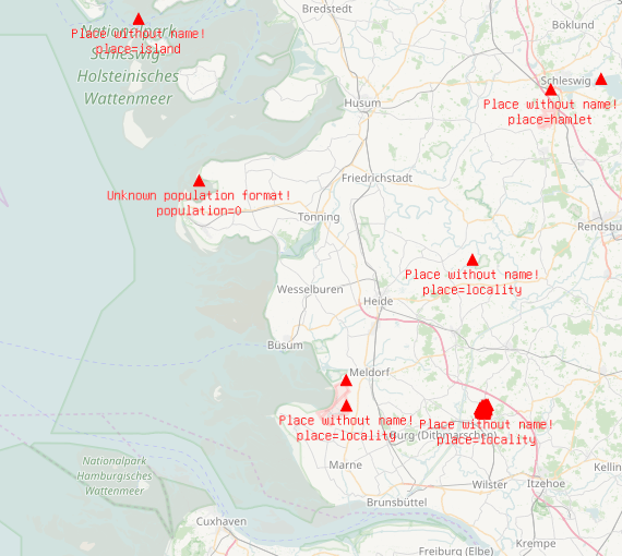
Places are a core feature of many maps and good data of places in OSM is important. But not only names are important, population numbers are a rather objective method to classify places of equal category and help map renderers to prefer the larger of two neighbouring cities.
The Places view (documentation) is a special-topic map showing places and only places above or without a base map. It highlights missing names and anomalies in the data.
place=neighbourhood and place=hamlet. They are not flagged as “unknown value” any more. We added two new layers for them.How should you reach a place if there is no way (highway=*)? Some checks are done by our Highways view (documentation). We did not change very much with this view:
deprecated was removed. It used to show highway=unsurfaced and highway=minor, two very old and deprecated tags which completely disappeared from OSM some time ago, i.e. the layer was empty.From now the processing software of almost all views are open source. You can search for the errors on your own, e.g. if you need more frequent updates.