
21.01.2026 | Michael Reichert
Today we added a new view to OSM Inspector rendering postal code boundaries.
In some regions, mappers map postcodes not only as tags on objects with an address (addr:postcode=*), but also in the form of postcode polygons.
The new view supports this endeavour by helping mappers see where postcodes are missing and where existing postcode areas overlap. As a side effect, it’s something we can show a potential customer when they come asking for “global postcode boundaries” – the view makes it clear what you can expect from OSM and what you can’t.
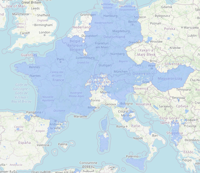
Postcode coverage is shown in semi-opaque blue. Polygons which overlap each other are yellow. Most of these are cases where both the administrative boundary and a second boundary object have a postal_code=* tag.
If postal_code=* is used on a polygon without boundary=*, it will appear as dark blue (low zoom) or orange lines (larger zoom level).
Keep in mind that OpenStreetMap primarily aims to collect ground truth. Administrative boundaries are an exception to this rule because they are considered relevant enough to include even if they cannot be observed on the ground. Post code boundaries are considered mappable in some regions and not so much in others – don’t go round adding post code boundaries in your area if the community doesn’t agree. Some countries have no postcodes at all or have postcode systems which cannot be modelled as polygons (e.g. Ireland). Therefore, there will never be a complete coverage.
The source code for the postcode view is on Codeberg.