
7.04.2026 | Frederik Ramm
We’ve recently added GeoPackage (gpkg) files to the download server, in addition to the shape files we’re already offering. This seems to be a popular addition; over half of the previous shape file download traffic has already migrated to the newer GeoPackage format – combining all layers in a single file, GeoPackage is more convenient than the old shape format.
But there’s more: We have updated the layer structure in the shape and GeoPackage files to include more data. You can review the details in our format specification PDF; the most important news is that the free data sets now contain an administrative area layer which was previously only available in the paid data sets*.
We’ve also added a protected areas layer and many POIs, but taken great care not to upset things too much so that people shouldn’t have to re-tool their processing chains built for previous versions of our shape files. Enjoy!
(*) Note that OSM doesn’t have a hierarchy of admin levels (i.e. city X is in county Y is in state Z) by default, and neither are boundaries clipped along the coastline. Administrative area shape files that have these extra features are available from us commercially.
10.09.2025 | Frederik Ramm
This month we’ve ramped up the infrastructure behind the download server, and downloads should now be available earlier
and faster. There’s also a small technical change in that requests for a “…latest” file will now be answered with a
HTTP redirect to the specific latest version (see previous blog post).
I would like to use this opportunity to appeal to users of the download server to “download responsibly”. We want
to continue offering this service as powerful and as convenient as possible within our means. We want everyone
to have easy access to the latest OSM data in a form that is useful to them.
Every now and then, people break things for others. There have been individual clients downloading the exact same
20-GB file 100s of times per day, for several days in a row. (Just the other day, one user has managed to download almost 10,000 copies of the italy-latest.osm.pbf file in 24 hours!) Others download every single file we have on the
server, every day. There’s a limit to the outgoing network bandwidth, and behaviour like this means that
things are slowing down for everyone. Also, when we block an IP range for abuse, innocent third parties can be affected.
Here’s three concrete appeals to users of the download server:
1. If you want data for the whole planet, don’t download it piecemeal from us – simply get the planet file from planet.openstreetmap.org and you’re done!
2. If you want a large region (like Europe or North America) updated daily, use the excellent pyosmium-up-to-date program which will automatically determine the age of your local file and update it by downloading the latest changes; this saves something like 98% of network traffic compared to a fresh download, and is faster.
3. If you automate anything with regard to our download server, monitor what your script is doing or build in appropriate catches so that you don’t end up downloading the same file 1000 times just because your disk is full or something like that.
Happy downloading!
24.07.2025 | Frederik Ramm
The Geofabrik dowload server is a wildly popular service that each month pushes out about 400 TB of OpenStreetMap data to users around the world – most of that in the form of country or regional .osm.pbf files. We publish these files with a date in the filename (e.g. germany-250723.osm.pbf) but for convenience we also have a downloadable file like “germany-latest.osm.pbf” that always gives you the most recent version.
Keeping these two as separate files does, however, interfere with caching; the proxies we use to speed up the download offering don’t know that “something-250723” and “something-latest” are the same file so they need to retrieve them both.
Starting 01 September, we’ll change this in line with best practices, and send a HTTP redirect if you request a “latest” file. The redirect then points the client to the appropriate URL with a data embedded in the file name. This should be transparent for most use cases, however if you have some sort of setup that does not follow HTTP redirects you might have to modify that. wget will follow redirects by default, whereas curl requires the command line flag -L.
26.06.2025 | Amanda McCann
Geofabrik is pleased to support the OpenStreetMap community as a bronze sponsor of two upcoming conferences in 2025:
We have been regular sponsors of SotM events for many years, including regional conferences such as FOSSGIS. Our staff have also contributed by speaking at various sessions over time.
Events like SotM offer a useful opportunity for exchange within the OpenStreetMap ecosystem. While much of the work in the OSM world happens remotely, occasional in-person meetings remain valuable for maintaining collaboration and perspective.
Sponsorship opportunities are still available for both events for those interested in supporting the community.
3.04.2025 | Frederik Ramm
In der letzten Woche waren drei von uns – Amanda, Michael und Frederik – auf der FOSSGIS-Konferenz in Münster. (Die Geofabrik ist auch Sponsor der FOSSGIS-Konferenz.) Die Veranstaltung, die jedes Jahr interessante Vorträge und Gespräche rund um alles im Open-Source-GIS-Bereich bietet, hatte dieses Mal rund 750 Besucher:innen und fand in den denkmalgeschützten Räumen im Schloss statt.
Alle Vorträge wurden vom CCC-Videoteam aufgezeichnet und können auf https://media.ccc.de/c/fossgis2025 angesehen werden. Amanda hat über ihr Projekt WaterwayMap gesprochen; Michaels Thema war, wie man in Deutschland noch neue Mapping-Aufgaben findet, und Frederik hat einen neuen OSM-Datenabfragedienst namens Postpass vorgestellt.
Der FOSSGIS e.V. hat auf seiner Mitgliederversammlung beschlossen, dass er Unternehmen und andere Organisationen, die OpenStreetMap nutzen, als „Förderer“ gewinnen will, um mehr Planungssicherheit für seine OpenStreetMap-Aktivitäten zu erreichen. Die Geofabrik hat natürlich gleich ja gesagt – wir sind die ersten! Unterstützen auch Sie die wertvolle OSM-Arbeit des FOSSIGS e.V., indem Sie Förderer werden.
21.03.2025 | Frederik Ramm
We’re happy to announce that we now have a nice public transport map, courtesy of Melchior Moos who runs the original öpnvkarte.de web site. Geofabrik now hosts its own version of that original “ÖPNVKarte” (“ÖPNV” is the German acronym for public transport), and we’ll be offering it to international customers under the somewhat simpler name “Public Transport Map”.
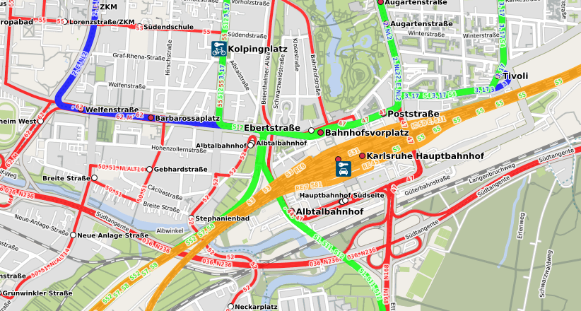
We’ll also approach the OpenStreetMap operations team and recommend this map for inclusion on www.openstreetmap.org which has featured ÖPNVKarte for a long time and only recently dropped it due to operational concerns.
This public transport map currently relies on a proprietary database importer written by Melchior Moos, but using the work contributed by our recent Geofabrik intern Max Hoogerdijk, we’re planning to publish import scripts compatible with osm2pgsql’s Themepark import mechanism under an open source license soon.